

A roadtrip through Proctor, Pittsford, Florence, Brandon, Shoreham
By Julia Purdy
Who doesn’t love the romance, intrigue and bucolic setting of a covered bridge? Vermonters are no different — Vermonters cherish our heritage of covered bridges, and the Vermont Historic Bridge Program, begun in 1988, is committed to keeping authentic public covered bridges in service wherever possible with preservation and authentic reproduction of replacement parts. Vermont Agency of Transportation partners with the towns to inventory and monitor bridge conditions and provide oversight of preservation and treatment standards with the use of state and federal dollars.
Below is the second of two self-guided tours by auto, motorcycle or bike. (The first tour was published in the Aug. 3-9 edition and can also be viewed online at mountaintimes.info/the-bridges-of-rutland-county-a-tour.)
Note: these bridges are all one-lane wide. Slow down and check for approaching vehicles and pedestrians before crossing. Turn on headlights and cross at a walking speed. Most bridges have small parking spots on either side. Please respect private property.
North covered bridge loop
This route follows a figure-8. Mileages are continuous except where noted.
Directions: Follow West Street (Business-4) to the RR trestle and bear right onto Route 3. At 4.5 miles bear left by the library and cross Otter Creek on the Marble Bridge (built 1913).
Follow the double yellow line. At 5.1 miles, turn right at the “T” onto Main Street. Continue on Main Street. At 5.5 miles, turn left onto Gorham Bridge Road. The bridge is located at 6.5 miles.
Bike lanes and level terrain make this a pleasant, easy ride alongside the rail line and serpentine curves of Otter Creek. A historical marker at the bridge explains the importance role Otter Creek has played in the Vermont story. You will pass several large buildings made of marble blocks – what is left of the Vermont Marble Company, once considered the largest mable producer in the world. Many monuments and buildings in Washington, D.C. and elsewhere used Vermont Marble stone, processed by European quarrymen and carvers brought here by the company.
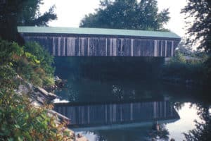
Gorham Covered Bridge, built in 1841, crossed the Otter Creek river in Proctor.
Stop No.1. Gorham Covered Bridge, Otter Creek, Proctor – 1841, Town lattice truss, 114’ long, entrance 9.5’ – Nichols Powers and Abe Owen, bridgewrights.
Located at the junction of Bridge Road in Proctor and Elm Street in Pittsford, Gorham Bridge crosses Otter Creek at a popular fishing spot. “Town lattice” refers to the widely used crisscross timber arrangement designed by civil engineer and architect of note Ithiel Town of Connecticut (1784-1844). Just before you reach the approach to the bridge, a stone marker on your left, decorated with British and American flags, commemorates the section of the Crown Point Military Road of 1756, which linked the Connecticut River with Lake Champlain, that crossed near here. Note the view through the bridge toward Killington and Pico. This bridge underwent a sweeping rehabilitation in 2003-2004, which carefully reproduced the original rotting structure.
Cross Gorham Bridge with caution! Covered bridge etiquette is look ahead and take turns crossing the bridge, with headlights on. At the end of the bridge, make a quick left onto Elm Street. At 7.4 miles, cross Cooley Bridge over Furnace Creek.
Stop No.2. Cooley Bridge, Furnace Brook, Pittsford – 1849, Town lattice truss, 60’ long, 10’9” tall – Nichols Powers, bridgewright. Listed on the National Register of Historic Places.
This little gem is a local favorite for obvious reasons. The Pittsford Town Trails network crosses Elm Street here, east to west toward Otter Creek. Fishing, snowshoeing, dog-walking, cross-country skiing are popular activities. Otter tracks can be seen in the winter snow.
From Cooley Bridge, continue on Elm Street to Route 7, marked by the Village Farm on the left and Kamuda’s Country Store, at 8.7 miles on the right. This stretch of Elm Street offers panoramic views of the Green Mountains to the east and the Pittsford Ridge to the west, with an unspoiled rolling landscape of hayfields and woods in between.
Caution! Before turning north (left) onto Route 7 at Kamuda’s store. The line of sight down Route 7 to your right is obstructed! You are advised to turn a sharp right onto Arch Street and drive a short distance to Mechanic Street, to access Route 7 safely. At 8.9 miles, turn left onto Depot Hill Road.
3. Stop No.3. Depot Bridge, Otter Creek, Pittsford – 1840 (restored 1974), Town lattice truss, 121’ long, 10.5’ high. Listed on the National Register of Historic Places.
Depot Bridge keeps watch over the lush Otter Creek floodplain, which lives up to its name every spring, making Depot Bridge inaccessible. Ducks, great blue heron, songbirds thrive here. Yes, there was once a Railroad depot here…
At 9.7 miles, at the stop sign turn right onto West Creek Road. A nice drive, with Pittsford Ridge and the Taconic Range to the west… Soaring elms, thick maples, lush pines, sparsely settled. At 11.1 miles, go through a very narrow underpass beneath a railroad spur that used to serve a quarrying operation. After the underpass, bear right. At 11.6 miles bear right again onto Kendall Hill Road, and at 11.8 miles arrive at the Hammond covered bridge.
4. Stop No.4. Hammond Bridge, Otter Creek, Pittsford – 1843 – 139’ long – Asa Nourse, bridgewright. Listed on the National Register of Historic Places.
In the Great Flood of 1927, the bridge was swept off its abutments and floated 1-1/2 miles downstream, intact. The townspeople put the bridge on barrels and floated it back upstream to its original location, where it now stands, although the modern highway bypasses it and the bridge is closed to vehicle traffic. A historic marker tells the story. Note also the Crown Point Military Road marker nearby.
Continue on Kendall Hill Road to Route 7 north into Brandon. At 19.3 miles arrive at Brandon town park. Bear around the park and continue through the business center. At 19.6 miles, turn left onto Pearl Street. At 20.8 miles, arrive at the Sanderson Covered Bridge.
5. Stop No.5. Sanderson Bridge, Otter Creek, Brandon – 1840 – Town lattice truss – 132’ long, 9.6’ high. Listed on the National Register of Historic Places.
In 2001 this bridge was deemed at risk of “imminent failure,” and was reconstructed authentically in 2002/2003. In 2019, it was damaged severely by a truck that was too tall, trying to cross it. Now, prominent signs on both ends tell drivers not to trust GPS and to turn around before they try to enter the bridge. Covered bridge openings, when built, were dimensioned to accommodate a loaded hay rick.
To return to Route 7, continue through Sanderson bridge. At 23 miles, bear left onto Short Swamp Road. At 24.1 miles, turn left onto Hack’s Sawmill Road, then left again at 24.7 miles onto High Pond Road. Continue on High Pond Road, at 26.1 miles, STOP.
Here you can (A) turn left to return to Brandon and Route 7 via Union Street, or (B) continue south on the Florence Road to Pittsford.
If you choose option B, at 30.2 miles you will be back at Kendall Hill Road and the Hammond Bridge. Turn left on Kendall Hill Road to reach Route 7. Turn south (right) to arrive at Kamuda’s store at 32.4 miles.
Continue on Route 7 into Rutland.
For RR buffs
6. East Shoreham Covered Railroad Bridge, Lemon Fair River, Shoreham – 1897 – Howe truss – 109’ long, 21’ high truss – Rutland Railroad Company. Listed on the National Register of Historic Places and the Historic American Engineering Record (HAER). Owned by the Vermont Division for Historic Preservation.
43°51’33”N – 73°15’22”W. Begin at the junction of US-7 and VT-73 mi. north of Brandon village center. Drive west alongside Otter Creek on the parkway-like Route 73 to the junction with Route 30 at mile 6. Turn right (north) on Route 30 and drive into Whiting center. Turn left (west) onto the Shoreham-Whiting Road and continue on Richville Road to Shoreham Depot Road at 12 miles. Turn left (south). Caution: blind hill! Continue to the bottom of the hill. The access to the bridge is on the right, marked by a Vermont Fish & Wildlife Management Area signpost.
The East Shoreham Covered Railroad Bridge is one of only two remaining railroad covered bridges in Vermont. Until 1951, it carried the Addison County Railroad to Larrabee’s Point in Shoreham, where the train crossed Lake Champlain on a floating bridge to Ticonderoga, New York. Access is an easy walk by a footpath on the old railbed from a small parking area just north of the bridge over the Lemon Fair. The origin of the river’s name remains a mystery; in spring its shallows are filled with wild yellow iris.
To return to Brandon by the scenic route: continue south on Shoreham Depot Road to Fisher Road at 13.7 miles, left then left again onto Murray Road at 14.3 miles. Continue on Murray Road to Route 30, then turn south (R) to the junction with Route 73 into Brandon.