By Julia Purdy
Who doesn’t love a covered bridge?
Nothing symbolizes Vermont’s heritage better than covered bridges – in fact, with just over 100 remaining publicly owned covered bridges out of originally 700-800, Vermont can boast more per square mile than anywhere else in the U.S. At one time, almost every public highway crossed a stream on a covered bridge. Many remain; many more have since succumbed to epic floods, vandalism or age and have been replaced by modern streamlined concrete spans, but the state Agency of Transportation Covered Bridge Program and the communities that own them, the Vermont Covered Bridge Society (vermontbridges.org) and scores of covered bridge fans, see to it that as many as possible are preserved and remain in service.

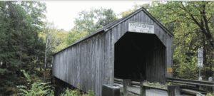
East Clarendon’s Kingsley bridge carries East Street across the Mill River.
Covered bridges have a mystique all their own. What better place to steal a kiss with your honey in the semi-darkness? There are local stories of robberies, murders, and hauntings. The floor booms and the openings frame unforgettable scenes of the countryside. Swallows and flycatchers nest in the beams.
Note: These bridges on these tours are all one-lane wide. Slow down and check for approaching vehicles and pedestrians before crossing. Turn on headlights and cross at a walking speed. Most bridges have small parking spots on either side. Please respect private property.
Rutland County is the setting for seven functioning (and one non-functioning) covered bridges within an easy drive of the city. Below is the first of two self-guided tours by auto, motorcycle or bike.
South covered bridge loop
Stop No. 1: North Clarendon – Brown Covered Bridge – 1880 – 100’ – carries the Upper Cold River Road across Cold River. Bridgewright: Nichols [sic] Powers. Listed as a National Historic Landmark, 2014.
To get there: Begin at Main Street Park, across from Christ the King Church. Go south on S. Main Street (Route 7) 1 mi and turn L onto Cold River Road. At the T, bear right 5.3 mi. to Upper Cold River Road on the left. This is a sudden left turn on a bend, so slow down and be alert to oncoming traffic. Parking at both ends of the bridge, with a historical marker and a trailhead into the new 1,349-acre, unspoiled Jim Jeffords State Forest.
Upper Cold River Road is 1 -lane packed dirt from Cold River Road, with a steep drop to the river. The downstream approach to the bridge was reduced to a footpath when Tropical Storm Irene sent a torrent down the gorge in 2011. Miraculously, the bridge survived as the river surged around it. Even more amazingly, one end of the bridge rests on a single, mammoth piece of exposed ledge. In 2016 the road was rebuilt and improved, and the bridge was restored authentically by a professional bridgewright.
Stop No. 2. East Clarendon – Kingsley Covered Bridge – 1836 – 121’ – crosses Mill River at Gorge Road –Bridgewright: Timothy Horton.
To get there: Continue on Upper Cold River Road. At 8.2 mi. turn right onto Wilmouth Hill Road (unmarked with a residence on the corner) and cross the bridge. Turn right onto Cold River Road. At 14.4 mi., turn left onto the North Shrewsbury Road and make an immediate left onto the East Clarendon Road. At 17.7 mi. turn left onto VT-103 and make a quick right onto Airport Road. At 18.2 mi. bear left onto Gorge Road. The Kingsley Covered Bridge is a short distance ahead.
The East Clarendon neighborhood is a cluster of private homes near the bridge and the Kingsley grist mill (private property), elements of a National Register District along with a 1778 house built by a Revolutionary War veteran who started a mill at the site. The operation included a sawmill and a grist mill, which functioned from 1882 to 1935. The district includes an 1885 horse barn, the 5-story mill building, and the remains of the mill dam.
Return to Rutland via the pretty farming community of Clarendon. Continue on Gorge Road to Route 7, then cross the highway into the village.
Note: As you enter the village, the fine 1823 Federal Style brick home on the left was the home of Nichols Powers, the reknowned builder with many covered bridges to his name as well as the Kingsley Grist Mill. Timothy Horton, who built the Kingsley Bridge, lived across the road from Powers. Both had direct access to the site via Gorge Road.
Continue on Middle Road due north. At the stop sign at 23.8 mi., return to Route 7 into Rutland by turning right onto Moulton Avenue OR continue straight ahead on Middle Road.
U-Tour No. 2 will feature six covered bridges in north Rutland County, plus a special bonus, one of the last two railroad covered bridges in the state.


