By Brett Yates
The town of Killington will consider a new plan for improving connectivity among its public mountain biking trails. Pedestrians, hikers, and transit riders would also benefit from the proposed infrastructural additions, which aim to link recreational amenities on Route 100 to commercial and community hubs on Route 4.
On Wednesday, Sept. 11, representatives from Vanasse Hangen Brustlin, Inc., hosted the last public meeting of the Killington Connecting Trails Scoping Study.

Courtesy town of Killington
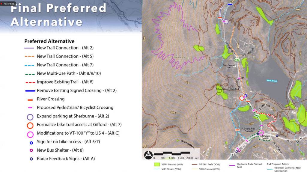
Map shows the most recent planned trail connections along routes 100 and 4.
A team of consultants and public officials have been investigating opportunities to ease passage across the busy highway that bisects the Sherburne Trails singletrack network, whose main starting point — though just 1 1/2 miles north of the Killington post office — currently requires a car for safe access.
Gifford Woods State Park and Kent Pond are even closer to town, but Route 4 and Route 100 are known for fast-moving traffic creating hazardous crossing for anyone on foot or on a bike.
In the future, new paths, trails, and marked crossings could remedy the problem. According to Project Manager Jenn Conley, feedback from residents at two prior meetings helped shape their prospective design.
“In between, we’ve done a lot of the more technical steps of looking at constraints — [there are] a lot of natural resource constraints in this area that we had to keep in mind. We look at different property ownership,” Conley said. “A number of factors go into how we start from a wide range of alternatives to how we distill down to what becomes the preferred alternative.”
Municipal officials will receive a final report later this month and ask the Killington Select Board for its endorsement. Engineering and construction would take place in a piecemeal process over the course of several years, during which the town would seek various grants to pay for different parts of the plan. Ultimately, the town could end up adopting some components and not others.
“There’s definitely going to be priorities,” Town Planner Lisa Davis Lewis said.
The recommendations include a multi-use path that would connect Killington Road to the Killington Deli & Marketplace via the back side of Killington Sports. It would subsequently cross to the north side of Route 4 and then run parallel to Route 100 to the state park.
Mountain bikers would also have the option of using a revamped logging road to get to Gifford Woods, starting behind the Greenbrier Inn. In the Base Camp Trails section, above the Kent Pond Access Road, there’d be a new trail on the east side of Route 100 that would continue northward and eventually join an existing trail to reach the Sherburne Trails trailhead.
Possibly as soon as next year, that entrance will gain a twin on the opposite side of the road, thanks to a planned spur that will offer a new way for riders to join the Pesky Cairn loop — and connect to the Sherburner, the most popular town trail— from the main (free) Sherburne Trails trailhead. (This summer, Gifford Woods State Park began changing $5 entry for riders accessing trails through its park, which is currently the only way to get to the Sherburner.)
Killington has already secured grant funding for that project.
“We need to have a structural engineer design a bridge to cross the Tweed River,” Lisa Davis Lewis told the Mountain Times. “We are currently in discussions with several engineers


