Staff report
The U.S. Forest Service issued its final plan for managing 72,000 acres of public and private land on June 16. The proposed Telephone Gap Integrated Resource Project area is located on the Green Mountain National Forest (GMNF) within the towns of Brandon, Chittenden, Goshen, Killington, Mendon, Pittsfield, Pittsford, and Stockbridge.
“The Telephone Gap project is designed to move the forest landscape toward desired resource conditions within the project area. Resource and public benefits of project activities include improved wildlife habitat, restored soils and wetlands, a sustained network of roads and trails, increased recreation opportunities, and timber harvesting to provide wood products for the local and regional economy while enhancing forest health and diversity,” the final notice from the U.S. Forest Service stated.
The Telephone Gap project EA analyzed four alternatives in detail (Alternatives A-D).
“It is my decision to select Alternative C for implementation. This decision is based on the results of the analysis documented in the Telephone Gap project EA [environmental assessment], supporting information in the project planning record, and comments received during the initial project scoping and Telephone Gap project preliminary EA comment periods,” wrote Jay Strand, project team leader with the Green Mountain National Forest and author of the final report. “I find Alternative C will best address the concerns specific to environmental effects identified from public comments while still meeting the project need,” he added. “Alternative C was developed primarily to address public issues regarding the amount of mature and old forests proposed for harvest including concerns this will negatively impact biodiversity and the forest capacity to sequester and store carbon. I have selected Alternative C for implementation because it addresses these concerns while still providing for multiple resource benefits. Alternative C also has less overall environmental effects compared to Alternative B for a range of resources of concern including forest habitat; carbon and greenhouse gas emissions; threatened, endangered and sensitive wildlife and plant species; and aquatic, soil, recreation, and visual resources. This is primarily due to Alternative C having less acres harvested, and fewer miles of temporary road constructed within the project area.”
The plan goes into effect immediately and will govern work in the Telephone Gap area through 2030.
Among other projects, the plan includes a maple tapping special use permit for a 10-year term on approximately 83 acres (up to 4,000 taps) on the south end of Blue Ridge.
It also plans for the removal of all or a portion of an existing dam structure and restore natural stream and wetland ecological processes east of Forest Road 232. “Removing the dam will allow natural hydrological functions to process sediment currently held behind the dam. Additionally, two existing culverts along Forest Road 57 will be replaced with structures to allow aquatic organism passage and flood resiliency,” Strand wrote.
The plan also authorizes the addition of trails for mountain biking, hiking and snowmobiling. This includes a segment of the Velomont Trail and associated connector trails transecting the project area. Additional system trails will be improved providing a more quality experience, and non-sustainable trails will be decommissioned.
A 10-vehicle parking area will be constructed at the existing log landing located at the end of Rockwell Road (Town Highway 83); and another 10-vehicle parking area will be constructed along Old Turnpike Road north of the National Forest System (NFS)/private land boundary. These additional parking areas will increase recreation access opportunities to the general public.
However, the final decision does not allow for the reconstruction of a hut that burned down.
“My decision does not approve the issuance of a special use permit to the Vermont Huts Association to construct, operate, and maintain a hut near South Pond at the location of a previous four-season lodge,” wrote Strand. “The rationale for the removal of the proposed hut from my decision is …. Diverse Backcountry Management Area Recreation Standard S-1 states: Construction of new developed recreational facilities shall be restricted to those needed for resource protection. The proposed construction of a hut to provide overnight recreation opportunities near South Pond does not comply with this standard. Deviation from standards requires a Forest Plan amendment. For this reason, the proposed issuance of a special use permit to the Vermont Huts Association to construct, operate, and maintain a hut near South Pond will not be approved as part of this Final Decision Notice.”
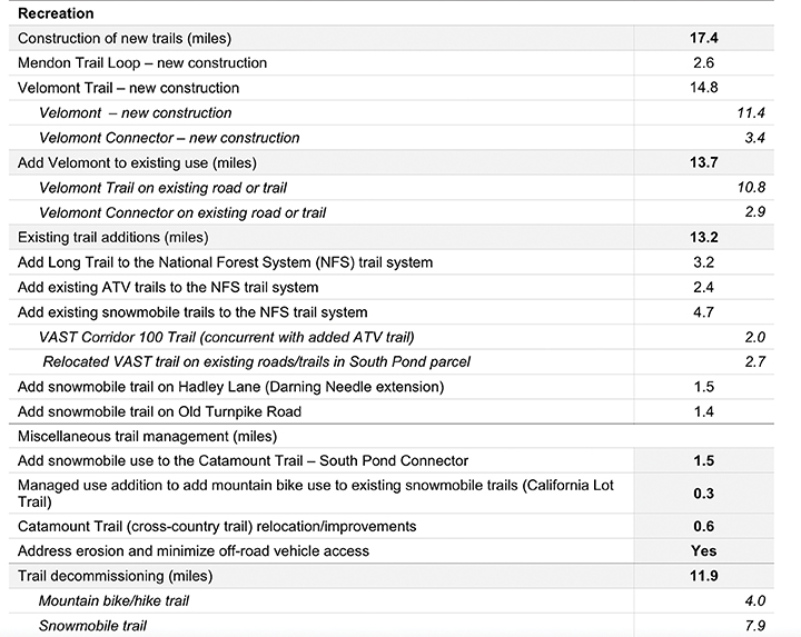
Chart shows the planned total miles of trails (left) and subcategories in each section (right).