
It was not just an unusually warm year, 2023 was a year of extremes throughout the state,
from flooding to cold snaps and heat waves
By Erin Petenko/VTDigger
By Erin Petenko/VTDigger, with data from National Weather Service
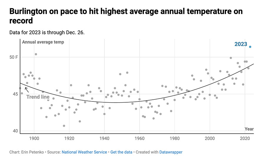
The chart above shows the average temperatures in Burlington since 1900. This past year, 2023, was well above average.
Vermont is on track to have its hottest average annual temperature in at least 127 years, according to National Weather Service data from the Burlington area— a stark sign of rising global temperatures brought on by climate change.
This past year has not only been the warmest on record, but it also has been rife with different forms of extreme weather throughout the state. Heat waves, cold snaps, flooding and wildfire-related air pollution have been among 2023’s notable weather events.
“It’s just been extremely wild in a number of different ways,” said Gabriel Langbauer, a meteorologist for the National Weather Service. “It’s not just been, ‘Oh, it’s warmer.’ It’s not just been, ‘Oh, we’ve had more thunderstorms.’ It’s all the different variables interacting. It’s all kinds of wonky stuff.”
Vermont is not alone. This year didn’t just break global temperature records — it blew past them, according to a New York Times analysis of federal weather data. Europe and the Southwestern United States were among the regions that experienced extreme heat waves in 2023.
Some climate scientists have suggested that the El Niño weather pattern is responsible for the particularly high temperatures this year. But Langbauer pointed out that at least in Vermont, 2023 is part of a broader swell of rising temperatures.
“If you look at the full list of the warmest years on record, they’re all in the last 10 years,” he said. “This is the trend we’re having, and it’s going to continue to be that way moving forward.”
By Erin Petenko/VTDigger, with data from National Weather Service
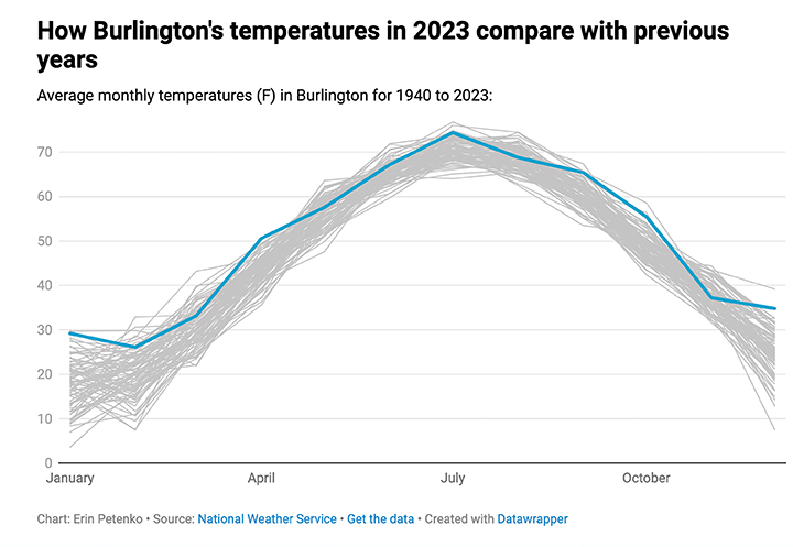
The chart shows the average temperature by month as recorded in Burlington since 1940. Every month was warmer than average .
Month-by-month data from the weather service reveals that Vermont started 2023 warm, with the fifth-hottest January ever recorded.
But February experienced the opposite extreme. Feb. 3, 2023, marked Vermont’s coldest day in 20 years, with wind chills causing a low of about -40 degrees, Langbauer said. Service organizations across the state scrambled to make sure Vermonters experiencing homelessness and other vulnerable people were prepared for the extreme cold.
Cold temperatures on May 18 also led to an unusually late frost after farmers had prepared for an early start to the growing season. Some farmers estimated a loss of 95% of their crop, leading Gov. Phil Scott to seek a disaster declaration from the U.S. Department of Agriculture.
The state then went through a record-breaking heat wave in early June, followed by several days of haze and air quality advisories from smoke blowing south from wildfires in Canada. Advocates expressed concern about the lack of cooling shelters for people living outside after some Vermonters were evicted from motels in early June. The northern regions of the state began reporting moderate drought conditions.
Then came July. On July 9-11, record-breaking rainfall of 5-9 inches swept through Vermont. From Ludlow in the south to Johnson in the north, the state experienced catastrophic flooding that inundated homes, businesses and local infrastructure. Montpelier’s North Branch River reported one of its highest-ever water levels of more than 526 feet.
In the weeks after the storm, the ground was so saturated that relatively minor rainfall forecasts set off flood warnings, again. Several communities experienced landslides that continued after the storms had passed.
And on Aug. 3, another round of rain hit Addison and Rutland counties, causing flooding in downtown Middlebury and Rutland, mudslides, and the closure of the Amtrak line.
Climate experts called the flooding a classic hallmark of the extreme weather patterns that climate change can cause. In total, the central Vermont region reported more than 20 inches of rain over the summer — the most it has received in 75 years.
“It’s been a very, very wet year all over the state,” Langbauer said.
The state then experienced another heat wave in early September, followed by a warmer-than-average October, according to weather service data.
The early days of winter saw cooler temperatures and several days of snowfall. Langbauer said higher elevations had greater-than-average snowpack in early December, allowing ski resorts to open on the early side.
But in mid-December, temperatures rose once again. A storm on Dec. 18 combined both rain and snowmelt to cause flooding across Vermont.
Looking ahead to the next few weeks, the weather service is predicting temperatures closer to normal for this time of year — that is, cold. Ski areas cross their fingers hoping that prediction is true.
For more information and data visit the National Weather Service archives at:weather.gov/ffc/archives.

Submitted