By Sarah Mearhoff/VTDigger
With hardly any debate, the Vermont Senate in a series of votes Friday, March 25, unanimously approved the House and Senate’s newly drawn legislative district lines. If approved and signed into law, the maps would stand for the next 10 years.

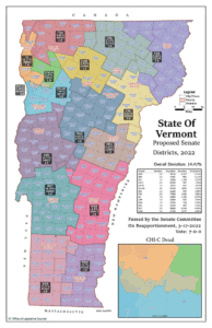
Map shows new Senate districts. Rutland County’s geographical boundary expanded slightly to meet the target threshold of 21,400 residents per senator. Windsor County remained the same.
In the upper chamber, senators debated how to fairly divide representation among just 30 senators across a state that saw dramatic population shifts in the past decade. Vermont’s population hub, Chittenden County, saw an influx of constituents, while the population declined in the Northeast Kingdom and portions of southern Vermont.
As a result, the state’s most rural region lost a senator to Chittenden County. The Northeast Kingdom, which includes Essex, Caledonia and Orleans counties, was previously represented by four senators. Under the new map, three would hail from the region.
Seven senators would now represent Chittenden County. The new map would also break up Chittenden County’s current and unusual six-member district as a result of a 2019 law prohibiting Senate districts with more than three members.
The proposed configuration in central and southern Vermont remained largely untouched, though Rutland County’s district swelled geographically to compensate for population loss.
Sen. Jeanette White, D-Windham, who chaired the Senate Reapportionment Committee, said during a joint caucus ahead of the vote that her committee considered roughly 30 different map options from beginning to end. She said both Republicans and Democrats have aired grievances about the final product, “so we must have done our job.” The final product distributes Vermont’s 30 senators across 16 districts. Each senator should represent as close to 21,400 constituents as possible.
House seats
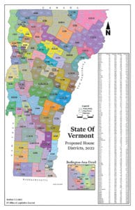
The debate around the House’s apportionment of its 150 members was driven by the existential question of whether to maintain Vermont’s unique multimember district model or to adopt a full single-member district map. Despite complaints from opponents, who contend that multimember districts are fundamentally unfair, representatives kept the multimember model.

Map shows new House districts. Nearly all districts in Rutland and Windsor county were reconfigured to some extent to hit the target of 4,287 residents per representative.
The House’s map divides representation among 150 representatives, who are to represent as close to 4,287 constituents as possible. The final map includes 68 single-member districts and 41 two-member districts.
The process was colored by the Legislature’s expedited timeline. Officials could not begin map-drawing until they had the 2020 census results, which were published late by the federal government due to the pandemic. Secretary of State Jim Condos gave state lawmakers an April 1 deadline to get the job done.
In an initial roll call vote Friday, senators voted 29-0 in favor of H.722, which includes the House and Senate maps. Senators cast a second, final vote, sending the bill back to the House, where representatives have yet to greenlight the Senate map. Then it would head to Gov. Phil Scott and Condos.
In an emailed statement, Scott spokesperson Jason Maulucci said that “there are always winners and losers” every reapportionment cycle, but Scott is particularly concerned about the trend of rural Vermonters losing representation in Montpelier.
“We see the consequences of the our (sic) demographic challenges in numerous ways, and the further redistribution of representation from rural areas to more economically well-off parts of the state are another example,” Maulucci said.


